Earthquake Source Model Database
Model/Event tag: s2007KURILI01HAYE
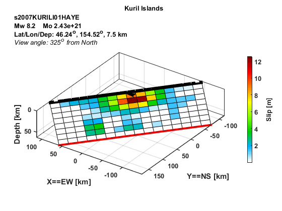
Event
| Author | Location | Date | Latitude (°N) | Longitude (°E) | Depth (km) | Flinn-Engdahl region |
| Hayes (2017) | Kuril Islands | Jan 13, 2007 | 46.2400 | 154.5200 | 7.50 | East Of Kuril Islands |
Source parameters
| Magnitude (Mw) |
Seismic moment (Nm) |
Strike (°) |
Dip (°) |
Rake (°) |
Length (km) |
Width (km) |
Htop (km) |
Hypocenter (km) | Avg rise time (s) |
Avg rupture speed (km/s) |
|
| x | z | ||||||||||
| 8.18 | 2.43E+21 | 220.00 | 39.00 | -106.20 | 320.00 | 92.96 | 3.84 | 170.00 | 5.81 | 4.27 | 2.41 |
Data source: Obtained electronically from the author.