Earthquake Source Model Database
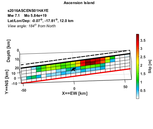
Model/Event tag: s2016ASCENS01HAYE
Event
| Author | Location | Date | Latitude (°N) | Longitude (°E) | Depth (km) | Flinn-Engdahl region |
| Hayes (2017) | Ascension Island | Aug 29, 2016 | -0.0718 | -17.8139 | 12.00 | North Of Ascension Island |
Source parameters
| Magnitude (Mw) |
Seismic moment (Nm) |
Strike (°) |
Dip (°) |
Rake (°) |
Length (km) |
Width (km) |
Htop (km) |
Hypocenter (km) | Avg rise time (s) |
Avg rupture speed (km/s) |
|
| x | z | ||||||||||
| 7.10 | 5.84E+19 | 79.00 | 85.00 | 176.27 | 110.00 | 16.50 | 3.78 | 52.50 | 8.25 | 2.02 | 1.00 |
Data source: Obtained electronically from the author.