Earthquake Source Model Database
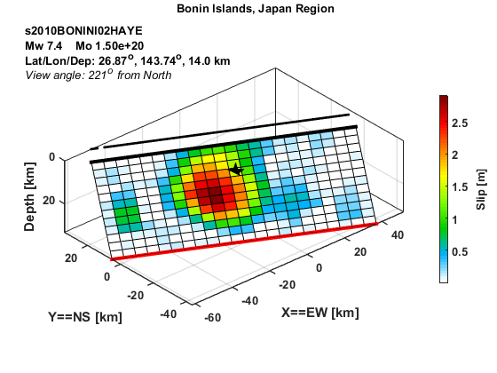
Model/Event tag: s2010BONINI02HAYE
Event
| Author | Location | Date | Latitude (°N) | Longitude (°E) | Depth (km) | Flinn-Engdahl region |
| Hayes (2017) | Bonin Islands | Dec 21, 2010 | 26.8656 | 143.7392 | 14.00 | Bonin Islands, Japan Region |
Source parameters
| Magnitude (Mw) |
Seismic moment (Nm) |
Strike (°) |
Dip (°) |
Rake (°) |
Length (km) |
Width (km) |
Htop (km) |
Hypocenter (km) | Avg rise time (s) |
Avg rupture speed (km/s) |
|
| x | z | ||||||||||
| 7.37 | 1.50E+20 | 116.32 | 40.35 | -124.36 | 110.00 | 42.00 | 6.06 | 57.50 | 12.25 | 2.01 | 1.36 |
Data source: Obtained electronically from the author.